Trimble SiteVision
Outdoor Augmented Reality System
The power of information, reimagined.
Imagine if you could see things that are hidden or that don’t actually exist yet. With the Trimble® SiteVision™ outdoor augmented reality system you can. SiteVision brings geospatial data to life so you can easily visualize, explore and understand complex information with unrivaled accuracy, right from your mobile device.
SiteVision unlocks and simplifies the use of geospatial information by allowing you to see your data in the real word - from property lines to underground services to conceptual designs - making it the ideal tool for public and contractor engagement in planning processes as well as throughout the project lifestyle.
With the demand to capture and update geospatial data accuracy and reliably, SiteVision helps create efficient deliverables and drive good decisions based on the best information available.
Streamlined, integrated solution
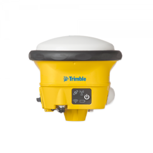
- Centimeter-accuracy GNSS positioning with the Trimble Catalyst™ software-based receiver
- Remote measurement with an Electronic Distance Measurement (EDM) rangefinder
- Flexible design fits user-supplied Android™ 9 phones (up to 8” screens)
- Waterproof and rugged
- Works handheld or pole-mounted
Easy-to-use software brings data to life
- Automatically place models on site, with centimeter-level accuracy
- View fully textured models in 3D, plan view or cross-section
- View any attributes in your model
- Adjust model opacity or cross-section to understand context
- View subsurface models with PitView
- Works seamlessly with your existing workflows and data; supports Trimble, open industry standard, and third-party file types: Trimble Business Center, SketchUp, Esri, AutoCAD
Key Features
- Accurately places and displays 2D/3D data in real world context from any angle at true-to-life scale
- Precisely locates and reveals hidden assets
- Combines Trimble® Catalyst™ GNSS centimeter-level positioning and electronic distance measurement (EDM) with Google® AR technology
- Automatically transforms complex 2D designs into visual 3D models
- Switches between 2D and 3D views
- Provides Trimble cloud-based data hosting and reporting tools
- Enables collaboration and communication of designs on the job site
- Compatible with a wide range of Trimble, open industry standard, and third-party file formats
- Lightweight, portable handheld or pole-mounted unit